
We had an earlier wake up call so we could get our luggage out for the bellboys to pickup. Then off to breakfast and a meeting before making sure our luggage got put on the bus. Today was a big travel day as we were leaving Cairo and headed for Mt. Sinai on the south end of the Sinai Peninsula (which is all still part of Egypt these days).
But before we left Cairo, we did two things. First we swung by Giza again so that the two couples
who arrived late could get to see them. And second, we went for a short sailboat ride on the Nile River. It was very overcast (smog) as well as cold and windy but again one of those things that was so neat to think that you were actually sailing on the Nile! We were floating around in downtown near a lot of the big major hotels - Hyatt and the Four Seasons.


After leaving the boat ride, we headed out of town. On our way we got to observe a bunch of neighborhoods like the one below. That was one of the biggest things to shock us about Cairo - the abject poverty. This is just a small sample of the housing conditions. Rebar is left hanging out of buildings so that another floor can be added on top at a later time. And trash gets piled up behind buildings in alleys or in some cases, out in the little canals running in the middle of the street.


Along the side, some Bedouin families had set up huts to sell handmade jewelry.


Our second Biblical stop was Elim, listed also in Exodus 15 as the place of 12 springs. We parked and went to walk down there but there was a Bedouin family that had made camp and so we turned back - their dogs sure didn't like us much!


And then it was off to bed - we were all snuggled in by 8pm because the wake up call for the morning climb on Mt. Sinai was coming super early!

As we left Cairo and headed towards the Sinai peninsula we went through a big military zone in Suez where we had to go through a checkpoint. At this point our police escort left us and headed back to town. The reason for the checkpoint is that people visiting Egypt can get two types of visas, one good for all of Egypt or one for the Sinai only. Egypt is interesting because it's a country on two continents - Cairo and what we most commonly associate with Egypt on the continent of Africa and the Sinai Peninsula is considered part of the continent of Asia.

We then crossed the Red Sea through the Gulf of Suez through the Ahmed Hamdi Tunnel, which runs underground for two miles. We were to have gone further north and made the crossing by overland bridge, but Egypt had closed that bridge out of concern for potential problems because of Gaza. Before going into the tunnel we could see some of the Suez Canal, which runs north and south for 100 miles connecting the Red Sea to the Mediterranean. It was operated by the British and French for almost a 100 years before Egypt's President Nasser nationalized it in 1956, helping raise big $ to pay for the Answan Dam on the Nile. Most everything else we saw was dry and dusty like this shot out the window of the bus.

As we traveled south through the Sinai Peninsula, we stopped at several places along the path of the Israelites' exodus from Egypt. The first stop was at Marah and was supposedly one of the first stops of the Israelites according to Exodus 15. After crossing the Red Sea they had traveled for three days without finding water. When they stopped at Marah, the water was salty so God told Moses to put a branch in the water and then it was "sweet" to drink. There are two wells there now - 1 wet and 1 dry. And in the background you can see the Gulf of Suez today.


Along the side, some Bedouin families had set up huts to sell handmade jewelry.


The government of Egypt has offered many times to help the Bedouins resettle from their nomadic life in the desert into small towns and cities so that their children can be educated. While some have accepted the offer, most refuse preferring their own traditions instead. We can see how it would be hard after living in such an open place for these people to move into a crowded city or town. However, in some cases the men will move into the cities to work and support their families back home. We saw no Bedouin men in this group - only women and children.
After a while we stopped off at what seemed like the only rest stop around and ate the box lunches our guide had arranged for us. There was so much food in all the boxes we couldn't possibly eat it all so as a group we collected all the extras and saved them to take later to some of the Bedouin children. A few more checkpoints, and then a long time of nothing but desert again.
Our second Biblical stop was Elim, listed also in Exodus 15 as the place of 12 springs. We parked and went to walk down there but there was a Bedouin family that had made camp and so we turned back - their dogs sure didn't like us much!


Another checkpoint got us into the St. Catherine area, which became much more hilly and elevated, about 3,000 ft above sea level. Our third stop was at Rephidim mentioned in Exodus 17 as another place where the Israelites needed water and here Moses was commanded to strike the rock for water. Also the Amalekites attacked the Israelites while they were here. Moses climbed up to the top of a hill and held his staff in the air - as long as his arms stayed up they won, but if they started to come down, the Israelites started losing. There are some monastery ruins here at the top where Moses was said to have stood - today the monstery has moved across the road.


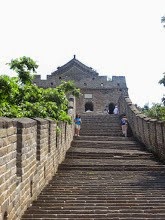
One last checkpoint got us into St. Catherine National Park for the hotel and Mt. Sinai. Here an armed guard entered the bus and checked everyone's passports and visas. Our hotel for one night was St. Catherine's Morgenland Village and we arrived in time for a brief meeting and dinner (this picture is actually from the next morning).

And then it was off to bed - we were all snuggled in by 8pm because the wake up call for the morning climb on Mt. Sinai was coming super early!
No comments:
Post a Comment